
Chicago Thunderstorms Today: Strong Winds and Flash Flooding Threat South of City
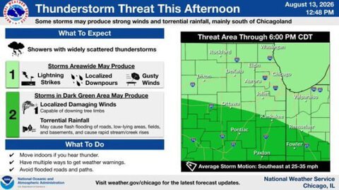
Chicago thunderstorms will continue developing across northern Illinois and northwestern Indiana Thursday afternoon, with the strongest storms expected mainly south of the Chicago metropolitan area.
Strongest Storms Expected South of Chicagoland
Areas around Ottawa, Pontiac, Kankakee, Paxton and nearby communities face the greatest threat through approximately 6 p.m. CDT.
Some thunderstorms could produce localized damaging winds capable of bringing down tree limbs and causing scattered power outages.
Torrential Rain Could Trigger Flash Flooding
Intense rainfall may quickly flood roads, low-lying locations, fields and areas near streams. Motorists should never attempt to cross a flooded road.
Storms will generally move southeast at 25 to 35 mph, potentially affecting parts of western Indiana later in the afternoon.
Residents Urged to Stay Weather Aware
Residents should keep multiple methods available to receive weather warnings and move indoors when thunder is heard.
People traveling across northern Illinois and northwestern Indiana should prepare for reduced visibility, standing water and rapidly changing conditions throughout the afternoon.



