
Illinois and Indiana Severe Thunderstorm Watch: 70 MPH Winds and Tornadoes Possible Until 7 PM
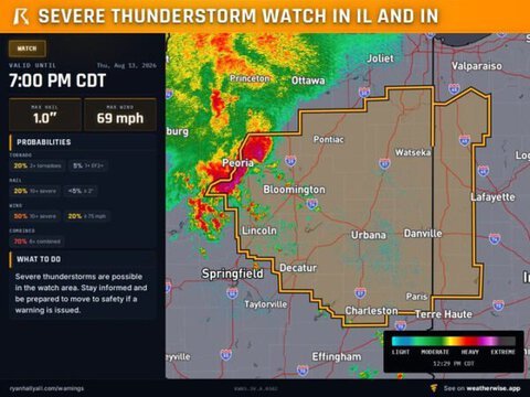
A Severe Thunderstorm Watch is in effect for east-central and northeastern Illinois and parts of western Indiana until 7 p.m. CDT Thursday, with damaging winds, large hail and isolated tornadoes possible.
Damaging Winds Could Reach 70 MPH
Powerful thunderstorms may produce widespread damaging wind gusts approaching 70 mph. Downed trees, power outages and property damage are possible across the watch area.
Tornado and Hail Threat
Forecasters say one or two tornadoes could develop, while isolated hail measuring up to one inch in diameter is also possible.
Communities near Springfield, Bloomington, Champaign, Danville, Joliet and Terre Haute are among the areas that could experience severe weather.
Residents Should Monitor Weather Alerts
People across Illinois and western Indiana should remain alert and be prepared to move to a secure interior room if a warning is issued.
Drivers should avoid flooded roads, while residents are advised to secure outdoor objects and keep phones charged in case of power outages.



