
Hurricane Isaias: Life-threatening storm surge, destructive winds and tornado threat continue across Gulf Coast
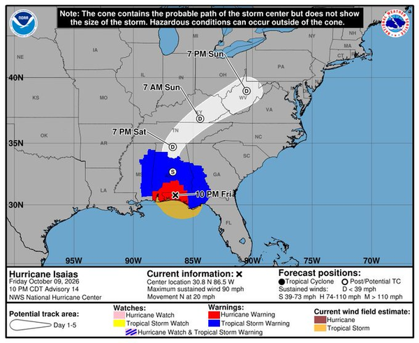
Hurricane Isaias continues to threaten the northern Gulf Coast with life-threatening storm surge, destructive hurricane-force winds, flooding and tornadoes as the storm moves toward the Florida Panhandle.
A Storm Surge Warning remains in effect from Dauphin Island, Alabama, to Suwannee, Florida, where dangerous coastal flooding is expected. Residents in the warning area should continue following evacuation orders and instructions from local officials.
Extremely dangerous hurricane-force winds, particularly powerful gusts, are expected across portions of the Florida Panhandle and southern Alabama. Residents are being urged to remain in a safe interior room and prepare for potentially long-duration power outages.
Damaging wind gusts are also possible across a broad portion of the Southeast, including western and northern Georgia, the southern Appalachians, central and northern Alabama, southern Middle Tennessee and Mississippi.
Heavy rainfall associated with Isaias is expected to continue across the central Gulf Coast and much of the Southeast through the weekend. Considerable flash flooding, urban flooding and significant river flooding are possible, while landslides could occur across parts of the southern Appalachians.
The tornado threat will continue overnight, with the greatest risk east of the storm’s center, particularly across the Florida Panhandle and into southern Georgia.
By the National Hurricane Center’s 7 p.m. CDT advisory, Isaias was nearing landfall in the western Florida Panhandle with maximum sustained winds of 110 mph and was located about 45 miles southeast of Pensacola.
Residents across the affected region should remain sheltered and continue monitoring official emergency alerts as conditions deteriorate overnight.
